Good Monday Morning, Friends of the Colorado River, You can't look at the news any…
How Much Sediment Is In Lake Powell?
How Much Sediment Is In Lake Powell?
Studies Are Needed
Guest post by By Gene Stevenson, Geologist, Bluff, Utah
September 26, 2018
Thirteen years following the completion of Hoover Dam in 1935 the first sediment study showed that 1.426 million acre feet (MAF) of fine sediment (clay, silt and sand) had accumulated in Lake Mead of which the majority had passed Lees Ferry gaging station. Few quantitative sedimentologic studies followed but one study estimated 54-60 million metric tons per year had been transported through Glen Canyon to Lees Ferry between 1949 and 1962 of which 40% was sand. Even though dams were built upstream as part of the CRSP in the early 1960s, a substantial amount of fine sediments continued to be transported into Glen Canyon primarily by the Colorado River and the San Juan River. For various reasons since Glen Canyon Dam was completed detailed bathymetric studies of Lake Powell have only been occasionally conducted, but hardly in any systematic and thorough way.
Those who have boated Cataract Canyon or the San Juan River certainly have experienced the muddy, silty waters and for those who boated these rivers in the pre-dam or pre-full pool periods (pre 1963 to 1984) and continued boating into the 21st century have witnessed some major sediment accumulations that have buried the former steep river gradients in the two river canyons. The rivers simply lost their capacities to carry the mass of suspended and bed load of sediments. The huge volume of sediments transported by these rivers quickly lowered gradients from many feet per mile to inches per mile and produced steadily advancing (prograding) deltas into the reservoir ~40 miles on the Colorado River and even more on the San Juan.
As the reservoir level continued to drop it left untold cubic miles of loosely consolidated sediments lining the incised river beds (Figure 1, below).

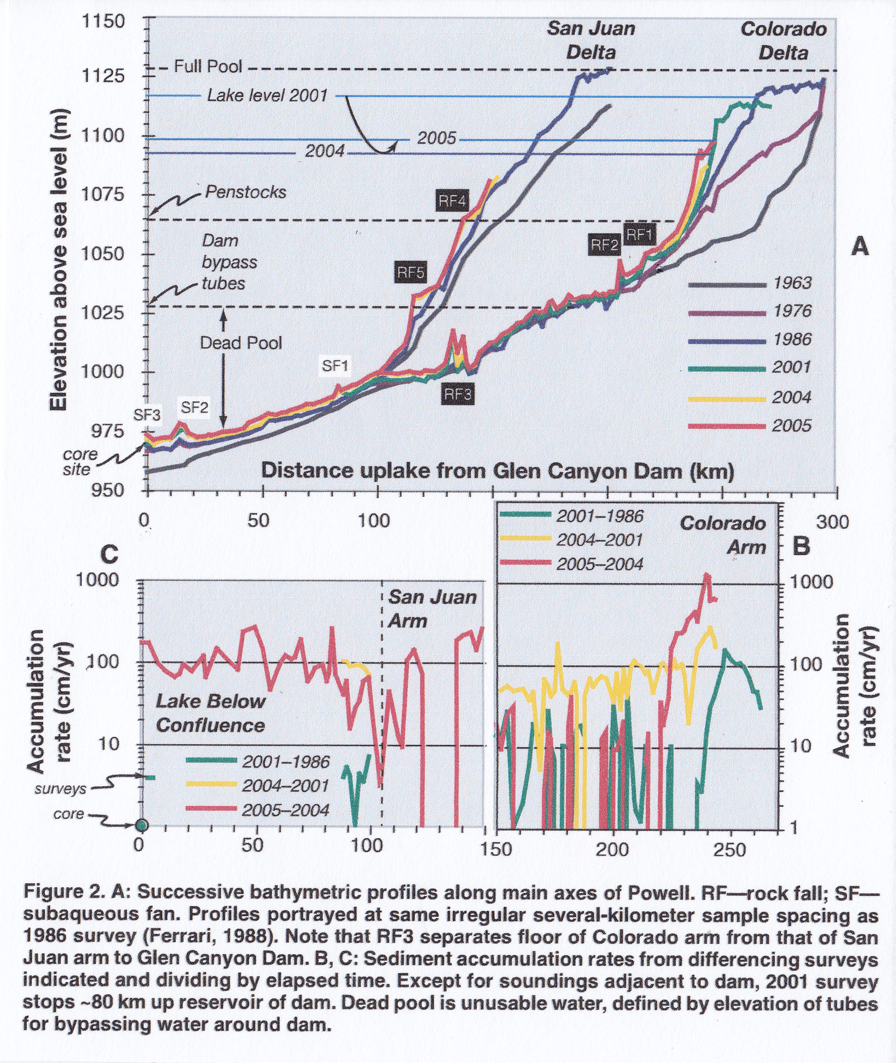
A study by Pratson, etal (2008; Figure 2, below)

The Lake Powell website (9/26/2018) indicates that lake level stands at ~3593 ft (1095 m) which is now 107 ft below full pool of 3700 ft above sea level. But full pool elevation is misleading in thinking there could be 27 MAF of water in the reservoir since that volume must include millions of metric tons of sediment as well as dead pool volumes of water, which is more than likely being displaced by turbidite transported sediments (see Schmidt, 2018, CRRG “Fill Mead First” proposal).
The Lake Powell web page shows there is 45.70% of 24.322 MAF of water above dead pool, or about 11.0 MAF of moveable, or useable water currently in the reservoir. Even if the Southwest’s climate were to reverse to a series of wet years, Powell reservoir will never be able to store 27 MAF of water as originally advertised. It never could. And with wet weather the up-river tributaries will produce higher run-off; higher run-off carries more sediment; exposed stranded stretches of unconsolidated river sediments will continue to be re-mobilized; and delta fronts, prodeltas and turbidity flows will increase in volume and frequency as sediments continue to pile up at the concrete wall of Glen Canyon Dam. Detailed sediment studies in Powell and Mead are long overdue and necessary so the general public can begin to really understand that these huge reservoirs were never designed to handle the incredible amount of sediment. They also need to learn that “Mother Nature always bats last!”
At the rate of drawdown on Powell reservoir, and the continued inflow of sediments, the call to drain Lake Powell will soon be a moot point and the efforts can switch from draining a dead pool to just simply removing the concrete barrier, and John Wesley Powell’s name can be properly cleansed and reclaimed by true conservationists.
*********
REFERENCES
Pratson, Lincoln, John Hughes-Clarke, Mark Anderson, Thomas Gerber, David Twitchell, Ronald Ferrari, Charles Nittrouer, Jonathan Beaudoin, Jesse Granet and John Crockett, 2008, Timing and patterns of basin infilling as documented in Lake Powell during a drought: Geology, November 2008, v. 36, no. 11; p. 843-846. Geological Soc. of America
Schmidt, John (Jack) C., 2018, Fill Mead First: a technical assessment; White Paper no. 1, Center for Colorado River Studies, Quinney College of Natural Resources, Utah State University; 4p. Summary
Shanmugan, G., 2001, Ten turbidite myths: Earth Science Reviews 58 (2002), p. 311-341.